
земельна ділянка під забудову 50 сот с. Дернівка, вул. Гайова
Телефон: 0672493786
Київська область


The prices of agricultural land and shares in Kyiv and the region differ from the average cost in Ukraine. A hectare costs on average 26.5 thousand UAH (980 $). When choosing a plot of land of 1 hectare, it is necessary to consider the type of soil, access roads, distance from the elevator, and the availability of infrastructure nearby. The market value of a hectare of black soil in the Kyiv region is determined by the topographical features, soil cover, geographical location, and climatic factors.
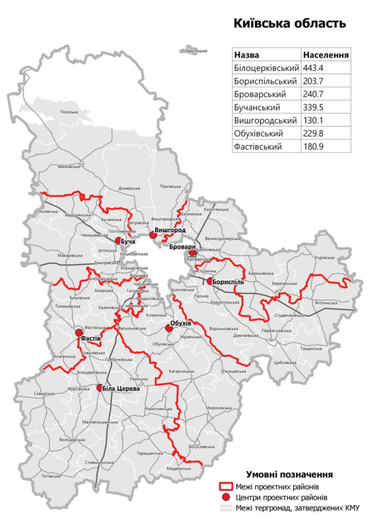
Kyiv region is located in the northern part of Ukraine in the basin of the middle flow of the Dnipro River. Kyiv city, as the regional center, is not part of the administrative structure. To the west, it borders Zhytomyr, to the southwest with Vinnytsia, to the south and southeast with Cherkasy, to the east – with Poltava and Chernihiv regions of Ukraine, and to the north it borders with the Homiel region of Belarus.
The area is 28,131 thousand km². The population is 1.783 million people. The State Land Cadastre contains data on agricultural land with an area of 1,609 thousand hectares. The area of drained land is 178.7 thousand hectares, and irrigated land is 123.8 thousand hectares.
Starting from July 17, 2020, the Resolution of the Verkhovna Rada of Ukraine divided Kyiv region into 7 districts.
| # | Name | Adm. center | Area of the district (thousand km²) |
| 1 | Bila Tserkva | m. Bila Tserkva | 6514.8 |
| 2 | Boryspil’sky | m. Boryspil | 3873.2 |
| 3 | Brovarskyi | m. Brovary | 2881.9 |
| 4 | Buchansky | m. Bucha | 2558.3 |
| 5 | Vishgorodsky | m. Vyshhorod | 4337.0 |
| 6 | Obukhivskyi | Obukhiv. | 3639.1 |
| 7 | Fastivsky | Fastiv | 1761.2 |
Cities with a population of over 15,000 people.
| Bila Tserkva | Vyshgorod |
| Brovary | Pereyaslav |
| Boryspil | Slavutych |
| Irpin | Yagotyn |
| Fastiv | Hostomel |
| Vishneve | Kotsiubynske |
| Vasylkiv | Ukrainka |
| Bucha | Berezan |
| Bojarka | Boguslav |
| Obukhiv | Skvira |
The area of the region occupies 4.7% of the territory of Ukraine. Agricultural lands cover 1,768 thousand hectares, of which arable land accounts for 1,321 thousand hectares. In its territory, in the central part, podzolic chernozems and gray forest soils are found; in the northern districts, sod-podzolic soils; in the south, low-humus deep chernozems are widespread; in the east, there are chernozems, meadow, swamp, and solonchak soils; the river valleys are rich in meadow, sod-gley, and swamp soils.
The relief of the Kyiv region is divided into three parts and resembles a hilly plain with a slope towards the Dnieper valley. The moderately continental mild climate with soil cover provides good yields of winter and spring wheat, corn, barley, sunflowers, rapeseed, soybeans, sugar beets, and greenhouse vegetables. There are 21 feed mills operating.
The features of the terrain and the climatic conditions ensure high demand for agricultural land. The launch of the Ukrainian land market with transparent rules opens up new opportunities for business – investments in the land fund. Renting, buying, or selling agricultural land can be done on our online resource with convenient search by cadastral numbers.
Comments